
Thank you for supporting this site ❤️
Make a donation
Make a donation
Gear up for your next adventure:
As an Amazon Associate, this site earns from qualifying purchases at no extra cost to you.
Ampas topographic map
Click on the map to display elevation.
Thank you for supporting this site ❤️
Make a donation
Make a donation
Gear up for your next adventure:
As an Amazon Associate, this site earns from qualifying purchases at no extra cost to you.
About this map
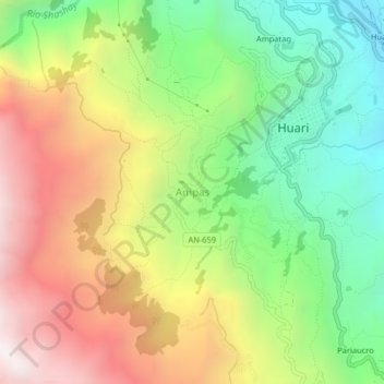
Name: Ampas topographic map, elevation, terrain.
Location: Ampas, Huari, Province of Huari, Ancash, Peru (-9.37518 -77.20290 -9.33518 -77.16290)
Average elevation: 11,414 ft
Minimum elevation: 9,403 ft
Maximum elevation: 13,891 ft
Thank you for supporting this site ❤️
Make a donation
Make a donation
Gear up for your next adventure:
As an Amazon Associate, this site earns from qualifying purchases at no extra cost to you.