Geolocate

Kongwa topographic map

Click on the map to display elevation.

About this map

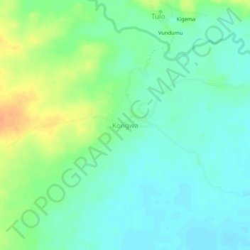
Name: Kongwa topographic map, elevation, terrain.

Location: Kongwa, Morogoro, Morogoro Region, Coastal Zone, Tanzania (-7.27327 37.89068 -7.23327 37.93068)

Average elevation: 364 ft

Minimum elevation: 322 ft

Maximum elevation: 440 ft

Other topographic maps

Click on a map to view its topography, its elevation and its terrain.

Kilombero

Tanzania > Morogoro Region

Average elevation: 1,562 ft

Kilosa

Tanzania > Morogoro Region

Average elevation: 2,730 ft

Ulanga

Tanzania > Morogoro Region

Average elevation: 1,496 ft

Mvomero

Tanzania > Morogoro Region

Average elevation: 1,857 ft

Mikumi National Park

Tanzania > Morogoro Region

Average elevation: 1,870 ft

Ulanga

Tanzania > Morogoro Region

Average elevation: 1,496 ft

Gear up for your next adventure:

🪓Survival Multi‑Tool - Versatile tool for camp and trail tasks
🔋Rechargeable Batteries - Power up your outdoor devices
🔋Solar Power Banks - Keep your GPS and phone charged in remote wilderness areas
🗻Climbing Gear Basics - Essential gear for beginner climbers
🧭Map Reading Tools - Tools and kits for map navigation

As an Amazon Associate, this site earns from qualifying purchases at no extra cost to you.