
Make a donation
Gear up for your next adventure:
As an Amazon Associate, this site earns from qualifying purchases at no extra cost to you.
Hastings topographic map
Click on the map to display elevation.
Make a donation
Gear up for your next adventure:
As an Amazon Associate, this site earns from qualifying purchases at no extra cost to you.
About this map
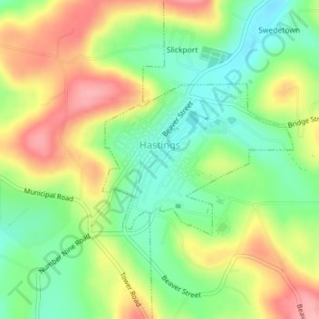
Name: Hastings topographic map, elevation, terrain.
Location: Hastings, Cambria County, Pennsylvania, 16646, United States (40.65737 -78.71867 40.67022 -78.69729)
Average elevation: 1,857 ft
Minimum elevation: 1,680 ft
Maximum elevation: 2,077 ft
Cambria County trails, hiking, mountain biking, running and outdoor activities
Make a donation
Gear up for your next adventure:
As an Amazon Associate, this site earns from qualifying purchases at no extra cost to you.
Other topographic maps
Click on a map to view its topography, its elevation and its terrain.
Saint Benedict
United States > Pennsylvania > Cambria County > West Carroll Township
Average elevation: 1,909 ft
Make a donation
Gear up for your next adventure:
As an Amazon Associate, this site earns from qualifying purchases at no extra cost to you.
Saint Boniface
United States > Pennsylvania > Cambria County > Elder Township
Average elevation: 1,946 ft
Make a donation
Gear up for your next adventure:
As an Amazon Associate, this site earns from qualifying purchases at no extra cost to you.
Saint Michael
United States > Pennsylvania > Cambria County > Adams Township
Average elevation: 1,775 ft
South Fork of the Little Conemaugh River
United States > Pennsylvania > Cambria County > Croyle Township > Rockville
Average elevation: 1,755 ft
Beaver Valley
United States > Pennsylvania > Cambria County > Clearfield Township
Average elevation: 1,614 ft
Make a donation
Gear up for your next adventure:
As an Amazon Associate, this site earns from qualifying purchases at no extra cost to you.
Belsano
United States > Pennsylvania > Cambria County > Blacklick Township
Average elevation: 1,788 ft
Make a donation
Gear up for your next adventure:
As an Amazon Associate, this site earns from qualifying purchases at no extra cost to you.