Geolocate

黄草 topographic map

Interactive map

Click on the map to display elevation.

About this map

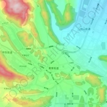
Name: 黄草 topographic map, elevation, terrain.

Location: 黄草, 兴义市, 黔西南布依族苗族自治州, 贵州省, 中国 (25.07380 104.87651 25.12254 104.91078)

Average elevation: 4,114 ft

Minimum elevation: 3,655 ft

Maximum elevation: 5,046 ft

Other topographic maps

Click on a map to view its topography, its elevation and its terrain.

桔山街道

中国 > 贵州省 > 兴义市

桔山街道, 兴义市, 黔西南布依族苗族自治州, 贵州省, 中国

Average elevation: 4,022 ft

南盘江镇

中国 > 贵州省 > 兴义市

南盘江镇, 兴义市, 黔西南布依族苗族自治州, 贵州省, 中国

Average elevation: 2,743 ft

兴义市

中国 > 贵州省 > 兴义市

兴义市, 黔西南布依族苗族自治州, 贵州省, 中国

Average elevation: 4,534 ft

万峰林景区

中国 > 贵州省 > 兴义市

万峰林景区, 万峰林, 兴义市, 黔西南布依族苗族自治州, 贵州省, 中国

Average elevation: 4,147 ft

万峰林

中国 > 贵州省 > 兴义市

万峰林, 兴义市, 黔西南布依族苗族自治州, 贵州省, 中国

Average elevation: 4,209 ft