
Make a donation
Gear up for your next adventure:
As an Amazon Associate, this site earns from qualifying purchases at no extra cost to you.
La Unión topographic map
Click on the map to display elevation.
Make a donation
Gear up for your next adventure:
As an Amazon Associate, this site earns from qualifying purchases at no extra cost to you.
La Unión
The locality is part of the Altiplano zone and is located in the highest part of the south of the San Nicolás Valley. The municipality has a complex mountain system, allowing it to have several thermal floors: of its total extension of 198 km², 136 km² comprise a cold climate (including the north, east, and south zones of the locality), and the remaining 62 km² (western area -El Guarango-) to a temperate climate. This allows for the cultivation of high Andean crops such as potatoes, uchuva, and lulo, to other temperate ones like coffee (to a lesser extent) and plantains. Another important geographic-geological feature is the maximum heights of 3050 m.a.s.l. at Cerro San Miguel (San Miguel Santa Cruz area) and 2737 m.a.s.l. at Morro Peñas (a prominence of the Antioquian batholith) located in the Vallejuelito-Peñas area (which is visible from much of the territory). The northern area is situated on a sedimentary plateau, rich in kaolin deposits; in contrast, the south is characterized by its rugged topography with volcanic soils, marking the beginning of the Sonsón Páramo system.
Make a donation
Gear up for your next adventure:
As an Amazon Associate, this site earns from qualifying purchases at no extra cost to you.
About this map
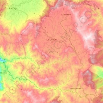
Name: La Unión topographic map, elevation, terrain.
Average elevation: 7,907 ft
Minimum elevation: 5,791 ft
Maximum elevation: 9,190 ft
Make a donation
Gear up for your next adventure:
As an Amazon Associate, this site earns from qualifying purchases at no extra cost to you.
Other topographic maps
Click on a map to view its topography, its elevation and its terrain.