
Make a donation
Gear up for your next adventure:
As an Amazon Associate, this site earns from qualifying purchases at no extra cost to you.
Mairiporã topographic map
Click on the map to display elevation.
Make a donation
Gear up for your next adventure:
As an Amazon Associate, this site earns from qualifying purchases at no extra cost to you.
Mairiporã
Mairiporã situa-se a uma altitude média de 790 metros. As partes mais altas do município estão na Serra da Cantareira, onde as altitudes superam os 1.100 metros em algumas regiões. Já as partes mais baixas estão no entorno do vale do Rio Juqueri e da Represa Paulo de Paiva Castro.
Make a donation
Gear up for your next adventure:
As an Amazon Associate, this site earns from qualifying purchases at no extra cost to you.
About this map
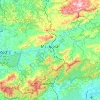
Name: Mairiporã topographic map, elevation, terrain.
Average elevation: 2,913 ft
Minimum elevation: 2,388 ft
Maximum elevation: 4,341 ft
Make a donation
Gear up for your next adventure:
As an Amazon Associate, this site earns from qualifying purchases at no extra cost to you.
Other topographic maps
Click on a map to view its topography, its elevation and its terrain.
São Paulo
Brasil > São Paulo > Região Metropolitana de São Paulo
A geologia local é constituída por terrenos policíclicos. representados por rochas metamórficas, migmatitos e granitoides, onde assentam-se sedimentos cenozoicos das bacias sedimentares locais. A altitude do município, tomando como referência o marco zero da cidade na Praça da Sé, é de 760 metros,…
Average elevation: 2,575 ft
Ilha Sumítica
Brasil > São Paulo > Região Metropolitana do Vale do Paraíba e Litoral Norte > Ilhabela
Average elevation: 3 ft
Piracicaba
Brasil > São Paulo > Região Metropolitana de Piracicaba > Piracicaba
No relevo de Piracicaba apresenta-se predominância de áreas acidentadas, sendo que a depressão é maior na parte central de seu território. Ela continua pelo sentido leste-oeste do curso do rio Piracicaba, aumentando sua acentuação no interior da zona urbana a partir do salto do rio Piracicaba. Essa…
Average elevation: 1,827 ft
Make a donation
Gear up for your next adventure:
As an Amazon Associate, this site earns from qualifying purchases at no extra cost to you.
Alagamento / Inundação
Brasil > São Paulo > Região Metropolitana de Piracicaba > Limeira
Average elevation: 1,864 ft
Santa Bárbara d'Oeste
Brasil > São Paulo > Região Metropolitana de Campinas > Santa Bárbara d'Oeste
Average elevation: 1,903 ft
Ferraz de Vasconcelos
Brasil > São Paulo > Região Metropolitana de São Paulo
Ferraz de Vasconcelos é um dos 39 municípios da Grande São Paulo, pertencente a região do Alto Tietê que contempla dez municípios, contando com uma densidade demográfica elevada e com alto índice de desenvolvimento humano - IDH, sua altitude em relação ao mar, situa-se entre 759 e 760 metros. Quando…
Average elevation: 2,546 ft
Make a donation
Gear up for your next adventure:
As an Amazon Associate, this site earns from qualifying purchases at no extra cost to you.
Ribeirão Preto
Brasil > São Paulo > Região Metropolitana de Ribeirão Preto > Ribeirão Preto
Average elevation: 1,834 ft
Rio Claro-SP
Brasil > São Paulo > Região Metropolitana de Piracicaba > Rio Claro
Average elevation: 2,005 ft
São Carlos
A bacia do córrego do Gregório, que nasce em área rural, a leste da cidade de São Carlos, numa região de aproximadamente 900 metros de altitude (onde nascem também o rio Monjolinho e o ribeirão dos Negros, importantes cursos d'água deste município). Tem como afluentes pela margem direita o córrego…
Average elevation: 2,546 ft
Make a donation
Gear up for your next adventure:
As an Amazon Associate, this site earns from qualifying purchases at no extra cost to you.
Ilha da Queimada Grande
A ilha possui aproximadamente 430.000m², topografia irregular e altitude máxima de 206 m. A profundidade ao redor pode chegar até 45 m. Não possui praias, somente costões rochosos. Um farol automático está instalado na parte mais plana da ilha, mantido e conservado pela Marinha.
Average elevation: 10 ft
Itaberaba
Brasil > São Paulo > Região Metropolitana de São Paulo > São Paulo
Average elevation: 2,477 ft
Make a donation
Gear up for your next adventure:
As an Amazon Associate, this site earns from qualifying purchases at no extra cost to you.
Pico do Jaraguá
Brasil > São Paulo > São Paulo
Pico do Jaraguá é um dos pontos mais altos do município de São Paulo, no Brasil, elevando-se a uma altitude de 1 135 metros. Situa-se no bairro do Jaraguá, a oeste da serra da Cantareira. Nos seus arredores, foi criado o Parque Estadual do Jaraguá, para conservação da área.
Average elevation: 2,828 ft
Morro do Capuava
Brasil > São Paulo > Região Metropolitana de São Paulo > Pirapora do Bom Jesus
Average elevation: 2,421 ft
Sorocaba
Brasil > São Paulo > Região Metropolitana de Sorocaba > Sorocaba
O relevo é classificado como ondulado, caracterizado por vertentes e altos de serra, com altitude média de 632 metros em relação ao nível do mar. A maior altitude é de 1.028 metros, nas cabeceiras do rio Pirajibu, na Serra de São Francisco, próximo a Alumínio. A menor altitude 539 metros está no vale…
Average elevation: 2,172 ft
Make a donation
Gear up for your next adventure:
As an Amazon Associate, this site earns from qualifying purchases at no extra cost to you.
Parque do Povo
Brasil > São Paulo > Região Metropolitana de São Paulo > São Paulo
Average elevation: 2,418 ft
Toque-Toque Grande
Brasil > São Paulo > Região Metropolitana do Vale do Paraíba e Litoral Norte > São Sebastião
Average elevation: 535 ft
Parque Municipal Chico Mendes
Brasil > São Paulo > Região Metropolitana de São Paulo > Osasco
Average elevation: 2,582 ft
Represa Paulo de Paiva Castro
Brasil > São Paulo > Região Metropolitana de São Paulo > Mairiporã
Average elevation: 2,566 ft
Make a donation
Gear up for your next adventure:
As an Amazon Associate, this site earns from qualifying purchases at no extra cost to you.
Toque-Toque Pequeno
Brasil > São Paulo > Região Metropolitana do Vale do Paraíba e Litoral Norte > São Sebastião
Average elevation: 466 ft
Morro do Pôr do Sol
Brasil > São Paulo > Região Metropolitana de São Paulo > São Paulo
Average elevation: 2,467 ft
Make a donation
Gear up for your next adventure:
As an Amazon Associate, this site earns from qualifying purchases at no extra cost to you.
Make a donation
Gear up for your next adventure:
As an Amazon Associate, this site earns from qualifying purchases at no extra cost to you.
Santa Branca
Brasil > São Paulo > Região Metropolitana do Vale do Paraíba e Litoral Norte > Santa Branca
Average elevation: 2,162 ft
Rio Cubatão
Brasil > São Paulo > Região Metropolitana da Baixada Santista > Cubatão
Average elevation: 30 ft
Dona Catarina
Brasil > São Paulo > Região Metropolitana de Sorocaba > Mairinque
Average elevation: 2,602 ft
Make a donation
Gear up for your next adventure:
As an Amazon Associate, this site earns from qualifying purchases at no extra cost to you.
Camburi
Brasil > São Paulo > Região Metropolitana do Vale do Paraíba e Litoral Norte > São Sebastião
Average elevation: 82 ft
Jundiaí
Jundiaí é um município brasileiro no interior do estado de São Paulo. Localiza-se a 23º11'11" de latitude sul e 46º53'03" de longitude oeste, a uma altitude de 762 metros. Dista 57 quilômetros de São Paulo. Conforme dados do Instituto Brasileiro de Geografia e Estatística (IBGE) de 2019, sua…
Average elevation: 2,651 ft
São Bento do Sapucaí
Brasil > São Paulo > Região Metropolitana do Vale do Paraíba e Litoral Norte > São Bento do Sapucaí > São Bento do Sapucaí
São Bento do Sapucaí é um município brasileiro do estado de São Paulo, situado na Serra da Mantiqueira. Localiza-se a uma latitude 22° 41'20" sul e a uma longitude 45° 43' 51" oeste, estando a uma altitude de 886 metros. Sua população, conforme estimativa do IBGE para 2020, era de 10 893 habitantes.
Average elevation: 3,314 ft
Make a donation
Gear up for your next adventure:
As an Amazon Associate, this site earns from qualifying purchases at no extra cost to you.
Serra do Mar
Brasil > São Paulo > Região Metropolitana do Vale do Paraíba e Litoral Norte > Ubatuba
Average elevation: 2,470 ft
Jardim São Paulo
Brasil > São Paulo > Região Metropolitana de Sorocaba > Sorocaba
Average elevation: 2,060 ft
Fazenda Boa Vista
Brasil > São Paulo > Região Metropolitana de Sorocaba > Sarapuí
Average elevation: 1,873 ft
Make a donation
Gear up for your next adventure:
As an Amazon Associate, this site earns from qualifying purchases at no extra cost to you.
Praça Ibrahim de Almeida Nobre
Brasil > São Paulo > Região Metropolitana de São Paulo > São Bernardo do Campo
Average elevation: 2,549 ft
Praça Conceição Aparecida de Souza Aguiar
Brasil > São Paulo > Região Metropolitana de São Paulo > São Paulo
Average elevation: 2,546 ft
Praça Mateus Leme
Brasil > São Paulo > Região Metropolitana de São Paulo > São Paulo
Average elevation: 2,533 ft
Parque em frente ao museu
Brasil > São Paulo > Região Metropolitana de São Paulo > Franco da Rocha
Average elevation: 2,510 ft
Make a donation
Gear up for your next adventure:
As an Amazon Associate, this site earns from qualifying purchases at no extra cost to you.
Rio Cotia
Brasil > São Paulo > Região Metropolitana de São Paulo > Carapicuíba
Average elevation: 2,520 ft
MAAS(Museu Aberto de Astronomia)
Brasil > São Paulo > Região Metropolitana de Campinas > Campinas
Average elevation: 3,081 ft
Praça Angélica Santiago Souza
Brasil > São Paulo > Região Metropolitana de São Paulo > São Paulo
Average elevation: 2,664 ft
Rio Juqueriquerê
Brasil > São Paulo > Região Metropolitana do Vale do Paraíba e Litoral Norte > Caraguatatuba
Average elevation: 696 ft
Make a donation
Gear up for your next adventure:
As an Amazon Associate, this site earns from qualifying purchases at no extra cost to you.
Centro
Brasil > São Paulo > Região Metropolitana da Baixada Santista > Santos
Average elevation: 46 ft
Parque Ecológico Municipal Zila Sisternas Fiorenzo – da Biquinha
Brasil > São Paulo > Região Metropolitana de Sorocaba > Sorocaba
Average elevation: 1,906 ft
Matinho
Brasil > São Paulo > Região Metropolitana de São Paulo > São Paulo
Average elevation: 2,579 ft
Ribeirão Jacuba
Brasil > São Paulo > Região Metropolitana de Campinas > Hortolândia
Average elevation: 1,991 ft
Make a donation
Gear up for your next adventure:
As an Amazon Associate, this site earns from qualifying purchases at no extra cost to you.
Rio Itaguaré
Brasil > São Paulo > Região Metropolitana da Baixada Santista > Bertioga
Average elevation: 10 ft
Praça da santa
Brasil > São Paulo > Região Metropolitana da Baixada Santista > Santos
Average elevation: 115 ft
Make a donation
Gear up for your next adventure:
As an Amazon Associate, this site earns from qualifying purchases at no extra cost to you.
Praça da Bíblia
Brasil > São Paulo > Região Metropolitana de Sorocaba > Cesário Lange
Average elevation: 2,041 ft
Jardim Itália
Brasil > São Paulo > Região Metropolitana de Sorocaba > Sorocaba
Average elevation: 1,886 ft
Praia de Pernambuco
Brasil > São Paulo > Região Metropolitana da Baixada Santista > Guarujá
Average elevation: 30 ft
Make a donation
Gear up for your next adventure:
As an Amazon Associate, this site earns from qualifying purchases at no extra cost to you.
Make a donation
Gear up for your next adventure:
As an Amazon Associate, this site earns from qualifying purchases at no extra cost to you.
Jardim Fátima
Brasil > São Paulo > Região Metropolitana de Sorocaba > Sorocaba
Average elevation: 1,870 ft
Pico dos Marins
Brasil > São Paulo > Região Metropolitana do Vale do Paraíba e Litoral Norte > Cruzeiro
O conjunto principal do Maciço dos Marins é constituído por três pontiagudos cumes de pedra, todos com mais de 2000 metros de altitude e centenas de metros de belos penhascos rochosos. O pico dos Marins, embora seja o mais elevado, é o mais acessível aos montanhistas, graças à sua face norte, menos…
Average elevation: 6,381 ft
Praça Professora Amélia Cesar Machado de Araújo
Brasil > São Paulo > Região Metropolitana de Sorocaba > Sorocaba
Average elevation: 2,014 ft
Make a donation
Gear up for your next adventure:
As an Amazon Associate, this site earns from qualifying purchases at no extra cost to you.
Ilhote Praia Grande
Brasil > São Paulo > Região Metropolitana da Baixada Santista > Guarujá
Average elevation: 174 ft
Praça Martinho Guedes
Brasil > São Paulo > Região Metropolitana de Sorocaba > Tatuí
Average elevation: 1,949 ft
Nascente (Afloramento D'água do Lençol Fréatico)
Brasil > São Paulo > Região Metropolitana de São Paulo > Franco da Rocha
Average elevation: 2,507 ft
Pedra da Mina
Brasil > São Paulo > Região Metropolitana do Vale do Paraíba e Litoral Norte > Queluz
A Pedra da Mina, ou ocasionalmente o pico da Pedra da Mina, é oficialmente a quarta montanha mais alta do Brasil, com 2798 metros de altitude.
Average elevation: 7,887 ft
Make a donation
Gear up for your next adventure:
As an Amazon Associate, this site earns from qualifying purchases at no extra cost to you.
Morro do Saboó
Brasil > São Paulo > Região Metropolitana de Sorocaba > São Roque
Average elevation: 2,543 ft
Ilha Porchat
Brasil > São Paulo > Região Metropolitana da Baixada Santista > São Vicente
Average elevation: 863 ft
Make a donation
Gear up for your next adventure:
As an Amazon Associate, this site earns from qualifying purchases at no extra cost to you.
Praça João Lino de Queiroz
Brasil > São Paulo > Região Metropolitana de Piracicaba > Leme
Average elevation: 2,034 ft
Condominio JD São pedro
Brasil > São Paulo > Região Metropolitana de São Paulo > Itapecerica da Serra
Average elevation: 2,530 ft
Make a donation
Gear up for your next adventure:
As an Amazon Associate, this site earns from qualifying purchases at no extra cost to you.
Parque Florestal Municipal Pedro Paes de Almeida
Brasil > São Paulo > Região Metropolitana de Sorocaba > Sorocaba
Average elevation: 1,913 ft
Mata de Transição entre dois biomas (Mata Atlântica e Cerrado)
Average elevation: 2,615 ft
Praia do Félix
Brasil > São Paulo > Região Metropolitana do Vale do Paraíba e Litoral Norte > Ubatuba
Average elevation: 404 ft
Make a donation
Gear up for your next adventure:
As an Amazon Associate, this site earns from qualifying purchases at no extra cost to you.
Brigadeiro Tobias
Brasil > São Paulo > Região Metropolitana de Sorocaba > Sorocaba
Average elevation: 2,198 ft
Parque Municipal Benemérito José Brás
Brasil > São Paulo > Região Metropolitana de São Paulo > São Paulo
Average elevation: 2,411 ft
Boiçucanga
Brasil > São Paulo > Região Metropolitana do Vale do Paraíba e Litoral Norte > São Sebastião
Average elevation: 246 ft
Parque Estadual da Cantareira Núcleo Pedra Grande
Brasil > São Paulo > Região Metropolitana de São Paulo > São Paulo
Average elevation: 2,674 ft
Make a donation
Gear up for your next adventure:
As an Amazon Associate, this site earns from qualifying purchases at no extra cost to you.
Pedra do Baú
Brasil > São Paulo > Região Metropolitana do Vale do Paraíba e Litoral Norte > São Bento do Sapucaí
Pedra do Baú (conhecido também como Complexo do Baú ou Complexo da Pedra do Baú) é um conjunto de rochas gnaissicas da Serra da Mantiqueira localizado no município de São Bento do Sapucaí, estado de São Paulo, Brasil. O ponto culminante é a Pedra do Baú (altitude de 1964 metros e 340 metros de…
Average elevation: 4,928 ft
Esmeralda Ville
Brasil > São Paulo > Região Metropolitana de Campinas > Campinas
Average elevation: 2,316 ft
Make a donation
Gear up for your next adventure:
As an Amazon Associate, this site earns from qualifying purchases at no extra cost to you.
Parque Estadual Da Serra Do Mar
Brasil > São Paulo > Região Metropolitana do Vale do Paraíba e Litoral Norte > São Luiz do Paraitinga
Average elevation: 3,150 ft
Bosque do Silêncio
Brasil > São Paulo > Região Metropolitana do Vale do Paraíba e Litoral Norte > Campos do Jordão
Average elevation: 5,404 ft
Make a donation
Gear up for your next adventure:
As an Amazon Associate, this site earns from qualifying purchases at no extra cost to you.