
Make a donation
Gear up for your next adventure:
As an Amazon Associate, this site earns from qualifying purchases at no extra cost to you.
Maad topographic map
Click on the map to display elevation.
Make a donation
Gear up for your next adventure:
As an Amazon Associate, this site earns from qualifying purchases at no extra cost to you.
About this map
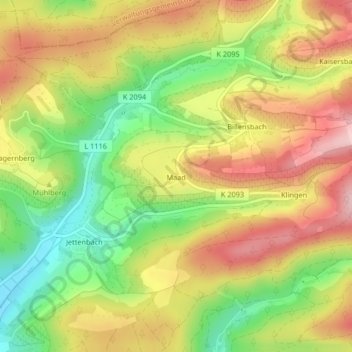
Name: Maad topographic map, elevation, terrain.
Average elevation: 1,171 ft
Minimum elevation: 823 ft
Maximum elevation: 1,499 ft
Make a donation
Gear up for your next adventure:
As an Amazon Associate, this site earns from qualifying purchases at no extra cost to you.
Other topographic maps
Click on a map to view its topography, its elevation and its terrain.
Stocksberg
Deutschland > Baden-Württemberg > Landkreis Heilbronn > Beilstein
Average elevation: 1,460 ft
Farnersberg
Deutschland > Baden-Württemberg > Landkreis Heilbronn > Beilstein
Average elevation: 1,207 ft
Gagernberg
Deutschland > Baden-Württemberg > Landkreis Heilbronn > Beilstein > Gagernberg
Gagernberg liegt im Schwäbisch-Fränkischen Wald etwa zwei Kilometer nordöstlich von Schmidhausen auf einer Anhöhe oberhalb des rechten Ufers des Schmidbachtals, das von Nordosten bei Löwenstein kommend nach Schmidhausen im Südwesten abfällt. Etwa 500 Meter nordwestlich von Gagernberg liegt im Wald der Annasee.
Average elevation: 1,083 ft