Geolocate

Dearborn Heights topographic map

Click on the map to display elevation.

About this map

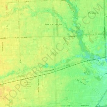
Name: Dearborn Heights topographic map, elevation, terrain.

Location: Dearborn Heights, Wayne County, Michigan, United States (42.26825 -83.31283 42.35706 -83.21769)

Average elevation: 623 ft

Minimum elevation: 581 ft

Maximum elevation: 646 ft

Wayne County trails, hiking, mountain biking, running and outdoor activities

Other topographic maps

Click on a map to view its topography, its elevation and its terrain.

Perrinville

United States > Michigan > Wayne County > Westland

Average elevation: 640 ft

Sunnyside

United States > Michigan > Wayne County > Romulus

Average elevation: 636 ft

Calvert Park

United States > Michigan > Wayne County > Detroit

Average elevation: 643 ft

Elm

United States > Michigan > Wayne County > Livonia

Average elevation: 640 ft

Newburg

United States > Michigan > Wayne County > Livonia

Average elevation: 686 ft

Dearborn

United States > Michigan > Wayne County > Dearborn

Average elevation: 623 ft

Gear up for your next adventure:

🪶Camping Sleeping Pad - Comfortable sleeping pad for backpacking
🪶Fire Starter Kit - Reliable fire starter for survival and camping
🚑Emergency Bivvies - Heat-reflective sleeping bags for survival situations
📌Outdoor GPS Map App - Apps and devices for digital topographic navigation
🧭Hiking Compass - Precision compass for reliable navigation in the wilderness

As an Amazon Associate, this site earns from qualifying purchases at no extra cost to you.