Geolocate

Caliclic topographic map

Click on the map to display elevation.

About this map

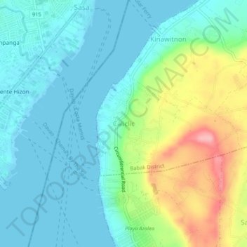
Name: Caliclic topographic map, elevation, terrain.

Location: Caliclic, Samal, Davao del Norte, Davao Region, Philippines (7.08592 125.64810 7.12592 125.68810)

Average elevation: 118 ft

Minimum elevation: -3 ft

Maximum elevation: 440 ft

Other topographic maps

Click on a map to view its topography, its elevation and its terrain.

Talicud

Philippines > Davao del Norte > Samal

Average elevation: 115 ft

Balet

Philippines > Davao del Norte > Samal

Average elevation: 207 ft

Adecor

Philippines > Davao del Norte > Samal

Average elevation: 289 ft

Kaputian

Philippines > Davao del Norte > Samal

Average elevation: 256 ft

Kinawitnon

Philippines > Davao del Norte > Samal

Average elevation: 148 ft

Peñaplata

Philippines > Davao del Norte > Samal

Average elevation: 89 ft

San Miguel

Philippines > Davao del Norte > Samal

Average elevation: 213 ft

Babak District

Philippines > Davao del Norte > Samal

Average elevation: 223 ft

Kinawitnon

Philippines > Davao del Norte > Samal

Average elevation: 148 ft

Peñaplata

Philippines > Davao del Norte > Samal

Average elevation: 89 ft

Peñaplata

Philippines > Davao del Norte > Samal

Average elevation: 89 ft

Talicud

Philippines > Davao del Norte > Samal

Average elevation: 115 ft

Gear up for your next adventure:

🧭Orienteering Set - Complete compass and map reading kit
🪑Ultralight Camp Chairs - Portable seating for resting after a long day of mapping
🧯Emergency Survival Kit - All‑in‑one survival essentials for the backcountry
🦺Reflective Outdoor Gear - Safety gear for low‑light conditions
👟Men's Trail Runners - Lightweight footwear for fast-paced exploration and light hiking

As an Amazon Associate, this site earns from qualifying purchases at no extra cost to you.