
Make a donation
Gear up for your next adventure:
As an Amazon Associate, this site earns from qualifying purchases at no extra cost to you.
Valkenberg topographic map
Click on the map to display elevation.
Make a donation
Gear up for your next adventure:
As an Amazon Associate, this site earns from qualifying purchases at no extra cost to you.
About this map
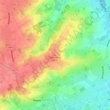
Name: Valkenberg topographic map, elevation, terrain.
Average elevation: 226 ft
Minimum elevation: 92 ft
Maximum elevation: 351 ft
Make a donation
Gear up for your next adventure:
As an Amazon Associate, this site earns from qualifying purchases at no extra cost to you.
Other topographic maps
Click on a map to view its topography, its elevation and its terrain.
Zwalmbeek
België > Oost-Vlaanderen > Oudenaarde > Nederbrakel
Door het Instituut voor natuur- en bosonderzoek van de Wetenschappelijke Instelling van de Vlaamse Gemeenschap werden op verschillende tijdstippen opnames gedaan van het visbestand op de Zwalm en enkele zijbeken. Op verschillende plekken (onder andere aan de Boembekemolen) werden vistrappen gebouwd; enkel ter…
Average elevation: 210 ft