
Thank you for supporting this site ❤️
Make a donation
Make a donation
Gear up for your next adventure:
As an Amazon Associate, this site earns from qualifying purchases at no extra cost to you.
Mörel topographic map
Click on the map to display elevation.
Thank you for supporting this site ❤️
Make a donation
Make a donation
Gear up for your next adventure:
As an Amazon Associate, this site earns from qualifying purchases at no extra cost to you.
About this map
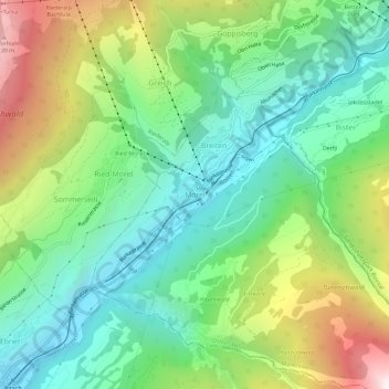
Name: Mörel topographic map, elevation, terrain.
Location: Mörel, Mörel-Filet, Östlich Raron, Wallis, 3983, Switzerland (46.33512 8.02436 46.37512 8.06436)
Average elevation: 4,081 ft
Minimum elevation: 2,277 ft
Maximum elevation: 7,664 ft
Thank you for supporting this site ❤️
Make a donation
Make a donation
Gear up for your next adventure:
As an Amazon Associate, this site earns from qualifying purchases at no extra cost to you.