Geolocate

Khashuri topographic map

Click on the map to display elevation.

About this map

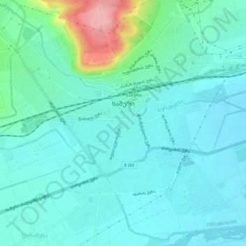
Name: Khashuri topographic map, elevation, terrain.

Location: Khashuri, Khashuri Municipality, Inner Kartli, 5700, Georgia (41.97695 43.56940 42.01133 43.62152)

Average elevation: 2,329 ft

Minimum elevation: 2,247 ft

Maximum elevation: 2,687 ft

Gear up for your next adventure:

🏕️Tent Footprint - Protect your tent base from wear
🔪Outdoor Multitools - Essential survival tools for gear repair and field use
👟Trail Running Shoes - Lightweight shoes for trail runners
🧣Merino Neck Gaiters - Multi-functional headwear for wind and sun protection
🪶Thermal Camp Blanket - Extra warmth for cold nights

As an Amazon Associate, this site earns from qualifying purchases at no extra cost to you.