
Make a donation
Gear up for your next adventure:
As an Amazon Associate, this site earns from qualifying purchases at no extra cost to you.
Bourgoin-Jallieu topographic map
Click on the map to display elevation.
Make a donation
Gear up for your next adventure:
As an Amazon Associate, this site earns from qualifying purchases at no extra cost to you.
Bourgoin-Jallieu
Bourgoin-Jallieu queda a una altitud media de 254 m. La ciudad se ubica a 42 km del centro de Lyon y a 70 km de Grenoble. Queda cerca de l'Isle-d'Abeau, La Verpilliere, Villefontaine y del aeropuerto de Lyon-Saint-Exupéry. Está atravesada por el río Bourbre.
Make a donation
Gear up for your next adventure:
As an Amazon Associate, this site earns from qualifying purchases at no extra cost to you.
About this map
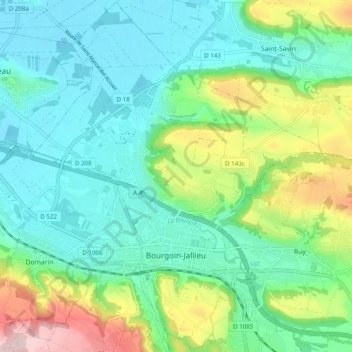
Name: Bourgoin-Jallieu topographic map, elevation, terrain.
Average elevation: 935 ft
Minimum elevation: 692 ft
Maximum elevation: 1,594 ft
Make a donation
Gear up for your next adventure:
As an Amazon Associate, this site earns from qualifying purchases at no extra cost to you.
Other topographic maps
Click on a map to view its topography, its elevation and its terrain.
Les Plagnes
Francia > Auvergne-Rhône-Alpes > Isère > Saint-Hilaire-de-Brens
Average elevation: 1,257 ft
Uriage Les Bains
Francia > Auvergne-Rhône-Alpes > Isère > Saint-Martin-d'Uriage
Average elevation: 2,028 ft
Les Bessonnets
Francia > Auvergne-Rhône-Alpes > Isère > Corrençon-en-Vercors
Average elevation: 4,167 ft
Make a donation
Gear up for your next adventure:
As an Amazon Associate, this site earns from qualifying purchases at no extra cost to you.