
Make a donation
Gear up for your next adventure:
As an Amazon Associate, this site earns from qualifying purchases at no extra cost to you.
Pussellawa topographic map
Click on the map to display elevation.
Make a donation
Gear up for your next adventure:
As an Amazon Associate, this site earns from qualifying purchases at no extra cost to you.
Pussellawa
The beginning of the Hill country, Pussellawa is 16 km from Gampola on A5 Nuwara Eliya road and has an elevation of nearly 2,800 feet (850 m) that makes the climate cool and surroundings can go under the mist during late evenings. Pussellawa Rest House was a popular stop with the early travellers, who rested prior to passing through the difficult mountains at Ramboda Pass onto Nuwara Eliya. The nearest Railway station is located in Gampola.
Make a donation
Gear up for your next adventure:
As an Amazon Associate, this site earns from qualifying purchases at no extra cost to you.
About this map
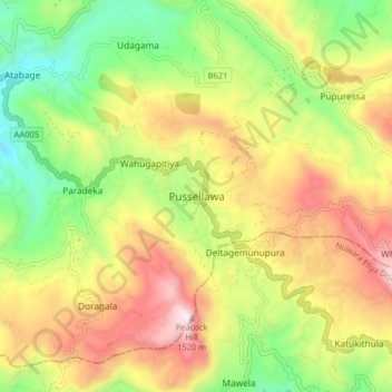
Name: Pussellawa topographic map, elevation, terrain.
Location: Pussellawa, Kandy District, Central Province, 20544, Sri Lanka (7.07015 80.59377 7.15015 80.67377)
Average elevation: 3,232 ft
Minimum elevation: 1,808 ft
Maximum elevation: 4,918 ft
Make a donation
Gear up for your next adventure:
As an Amazon Associate, this site earns from qualifying purchases at no extra cost to you.
Other topographic maps
Click on a map to view its topography, its elevation and its terrain.
Make a donation
Gear up for your next adventure:
As an Amazon Associate, this site earns from qualifying purchases at no extra cost to you.
Horton Plains National Park
Horton Plains National Park (Sinhala: හෝර්ටන් තැන්න ජාතික උද්යානය, romanized: Hortan Thanna Jathika Udyanaya) is a national park in the central highlands of Sri Lanka that was designated in 1988. It is located at an elevation of 2,100–2,300 m (6,900–7,500…
Average elevation: 6,594 ft
Horton Plains National Park
Horton Plains National Park (Sinhala: හෝර්ටන් තැන්න ජාතික උද්යානය, romanized: Hortan Thanna Jathika Udyanaya) is a national park in the central highlands of Sri Lanka that was designated in 1988. It covers an area of 31km² and borders Thotupalakanda Nature…
Average elevation: 6,594 ft
Make a donation
Gear up for your next adventure:
As an Amazon Associate, this site earns from qualifying purchases at no extra cost to you.