
Make a donation
Gear up for your next adventure:
As an Amazon Associate, this site earns from qualifying purchases at no extra cost to you.
Kühlenthal topographic map
Click on the map to display elevation.
Make a donation
Gear up for your next adventure:
As an Amazon Associate, this site earns from qualifying purchases at no extra cost to you.
About this map
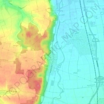
Name: Kühlenthal topographic map, elevation, terrain.
Location: Kühlenthal, Nordendorf, Augsburg (district), Bavaria, Germany (48.55177 10.76918 48.58538 10.82901)
Average elevation: 1,463 ft
Minimum elevation: 1,375 ft
Maximum elevation: 1,614 ft
Make a donation
Gear up for your next adventure:
As an Amazon Associate, this site earns from qualifying purchases at no extra cost to you.
Other topographic maps
Click on a map to view its topography, its elevation and its terrain.
Leuthau
Germany > Bavaria > Augsburg (district) > Schwabmünchen > Klimmach
Average elevation: 1,893 ft
Westendorf
Germany > Bavaria > Augsburg (district) > Westendorf > Westendorf
Average elevation: 1,430 ft