
Make a donation
Gear up for your next adventure:
As an Amazon Associate, this site earns from qualifying purchases at no extra cost to you.
Zulzeke topographic map
Click on the map to display elevation.
Make a donation
Gear up for your next adventure:
As an Amazon Associate, this site earns from qualifying purchases at no extra cost to you.
About this map
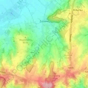
Name: Zulzeke topographic map, elevation, terrain.
Location: Zulzeke, Kluisbergen, Oudenaarde, East Flanders, Belgium (50.75922 3.55585 50.80129 3.58780)
Average elevation: 217 ft
Minimum elevation: 26 ft
Maximum elevation: 505 ft
Make a donation
Gear up for your next adventure:
As an Amazon Associate, this site earns from qualifying purchases at no extra cost to you.
Other topographic maps
Click on a map to view its topography, its elevation and its terrain.
Make a donation
Gear up for your next adventure:
As an Amazon Associate, this site earns from qualifying purchases at no extra cost to you.
Oude Kwaremont
Belgium > East Flanders > Oudenaarde > Kluisbergen
The lower 600 m of the climb consist of a narrow asphalt road, the upper 1600 m are paved with cobblestones. The first 500 m of cobbled section are particularly difficult, it is the steepest and narrowest part of the climb with a bad, very uneven cobbled surface. Halfway up the climb, near the church of…
Average elevation: 118 ft