Geolocate

Jeff topographic map

Click on the map to display elevation.

About this map

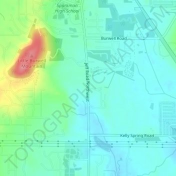
Name: Jeff topographic map, elevation, terrain.

Location: Jeff, Madison County, Alabama, 35749, United States (34.81287 -86.72361 34.83287 -86.70361)

Average elevation: 814 ft

Minimum elevation: 745 ft

Maximum elevation: 1,037 ft

Madison County trails, hiking, mountain biking, running and outdoor activities

Other topographic maps

Click on a map to view its topography, its elevation and its terrain.

Triana

United States > Alabama > Madison County

Average elevation: 584 ft

New Market

United States > Alabama > Madison County

Average elevation: 912 ft

Hazel Green

United States > Alabama > Madison County

Average elevation: 784 ft

New Hope

United States > Alabama > Madison County

Average elevation: 597 ft

Gear up for your next adventure:

🔦Powerful Headlamps - Ultra-bright hands-free lighting for night navigation
👓Polarized Sunglasses - Outdoor sunglasses for glare reduction
🔥Plasma Lighters - Windproof lighters that work in any weather condition
🎒Trekking Poles - Sturdy poles for balance and stability on rough terrain
GPS Sports Watch - GPS watch for running, hiking and training

As an Amazon Associate, this site earns from qualifying purchases at no extra cost to you.