
Thank you for supporting this site ❤️
Make a donation
Make a donation
Gear up for your next adventure:
As an Amazon Associate, this site earns from qualifying purchases at no extra cost to you.
Folta topographic map
Click on the map to display elevation.
Thank you for supporting this site ❤️
Make a donation
Make a donation
Gear up for your next adventure:
As an Amazon Associate, this site earns from qualifying purchases at no extra cost to you.
About this map
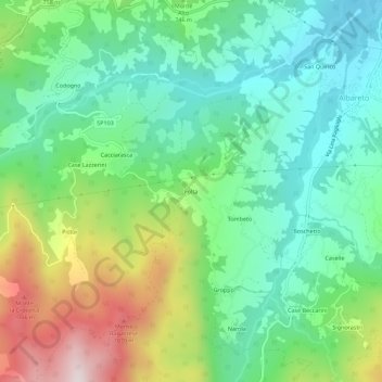
Name: Folta topographic map, elevation, terrain.
Location: Folta, Albareto, Parma, Emilia-Romagna, 43051, Italia (44.41670 9.65608 44.45670 9.69608)
Average elevation: 2,283 ft
Minimum elevation: 1,529 ft
Maximum elevation: 3,878 ft
Thank you for supporting this site ❤️
Make a donation
Make a donation
Gear up for your next adventure:
As an Amazon Associate, this site earns from qualifying purchases at no extra cost to you.