Geolocate

Bitan-agan topographic map

Click on the map to display elevation.

About this map

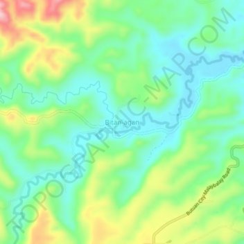
Name: Bitan-agan topographic map, elevation, terrain.

Location: Bitan-agan, Butuan, Caraga, Philippines (8.82919 125.50894 8.86919 125.54894)

Average elevation: 249 ft

Minimum elevation: 26 ft

Maximum elevation: 705 ft

Gear up for your next adventure:

🪶Camp Gear Gift Set - Perfect gift bundle for outdoor fans
🪶Compact Camp Shovel - Folding shovel for campsite tasks
🥘Titanium Cookware - Durable, featherlight pots and pans for backpacking
💧Water Purification System - Clean water on the trail with reliable purifiers
🎒Hydration Pack - Hands‑free water reservoir for long hikes

As an Amazon Associate, this site earns from qualifying purchases at no extra cost to you.