
Make a donation
Gear up for your next adventure:
As an Amazon Associate, this site earns from qualifying purchases at no extra cost to you.
Porto Quadro topographic map
Click on the map to display elevation.
Make a donation
Gear up for your next adventure:
As an Amazon Associate, this site earns from qualifying purchases at no extra cost to you.
About this map
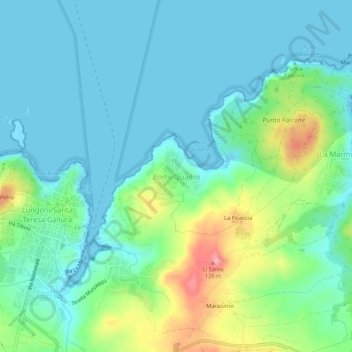
Name: Porto Quadro topographic map, elevation, terrain.
Average elevation: 95 ft
Minimum elevation: -3 ft
Maximum elevation: 384 ft
Make a donation
Gear up for your next adventure:
As an Amazon Associate, this site earns from qualifying purchases at no extra cost to you.
Other topographic maps
Click on a map to view its topography, its elevation and its terrain.
Sant'Antonio di Gallura
Il territorio comunale è situato su una collina di 357 metri di altitudine ed è circondato da profonde vallate e boschi di querce che ne fanno un paese di tradizione agropastorale. Comprende la parte orientale del lago artificiale Liscia.
Average elevation: 1,122 ft
Make a donation
Gear up for your next adventure:
As an Amazon Associate, this site earns from qualifying purchases at no extra cost to you.