
Make a donation
Gear up for your next adventure:
As an Amazon Associate, this site earns from qualifying purchases at no extra cost to you.
Seibelseckle topographic map
Click on the map to display elevation.
Make a donation
Gear up for your next adventure:
As an Amazon Associate, this site earns from qualifying purchases at no extra cost to you.
Seibelseckle
Das Seibelseckle ist eine Passhöhe (955,6 m ü. NHN) im Hauptkamm des nördlichen Schwarzwalds. Der Name bezeichnet außerdem die oberhalb davon an der Nordseite des Schwarzkopfs gelegene Skipiste mit Liftbetrieb an der Schwarzwaldhochstraße.
Make a donation
Gear up for your next adventure:
As an Amazon Associate, this site earns from qualifying purchases at no extra cost to you.
About this map
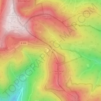
Name: Seibelseckle topographic map, elevation, terrain.
Average elevation: 3,074 ft
Minimum elevation: 1,995 ft
Maximum elevation: 3,816 ft
Make a donation
Gear up for your next adventure:
As an Amazon Associate, this site earns from qualifying purchases at no extra cost to you.
Other topographic maps
Click on a map to view its topography, its elevation and its terrain.
Mummelsee
Deutschland > Baden-Württemberg > Ortenaukreis > Seebach
Der Mummelsee ist ein Karsee auf 1028,5 m ü. NN Höhe am Abhang der Hornisgrinde im Schwarzwald. Er ist 3,7 Hektar groß und 18 Meter tief. Er zählt zu den meistbesuchten Seen in Baden-Württemberg, da er direkt an der Schwarzwaldhochstraße liegt. Die touristischen Einrichtungen am See bilden den Wohnplatz…
Average elevation: 3,025 ft