
Volcano topographic map
Click on the map to display elevation.
Volcano
Its altitude ranges from below 2,800 feet (850 m) in the southeast to over 6,200 feet (1,900 m) at its uninhabited northern end. Due to this, Volcano features a subtropical highland climate (Köppen Cfb), with relatively uniform temperatures and abundant rainfall throughout the year, although rainfall is concentrated during the months of November through April.
About this map
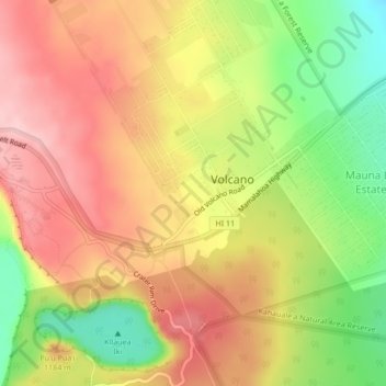
Name: Volcano topographic map, elevation, terrain.
Location: Volcano, Hawaiʻi County, Hawaii, 96785, United States (19.40835 -155.25828 19.44835 -155.21828)
Average elevation: 3,753 ft
Minimum elevation: 3,406 ft
Maximum elevation: 4,019 ft
Hawaiʻi County trails, hiking, mountain biking, running and outdoor activities
Other topographic maps
Click on a map to view its topography, its elevation and its terrain.
Kukuihaele CDP
United States > Hawaii > Hawaiʻi County
Kukuihaele is located on the north side of the island of Hawaii at 20°7′10″N 155°34′16″W / 20.11944°N 155.57111°W / 20.11944; -155.57111 (20.119536, -155.571160). It sits at an elevation of 730 feet (220 m) atop cliffs overlooking Waipio Bay. Hawaii Route 240 passes through the southern…
Average elevation: 568 ft