
Make a donation
Gear up for your next adventure:
As an Amazon Associate, this site earns from qualifying purchases at no extra cost to you.
Pico Llen topographic map
Click on the map to display elevation.
Make a donation
Gear up for your next adventure:
As an Amazon Associate, this site earns from qualifying purchases at no extra cost to you.
Pico Llen
Peña Cabarga es un macizo calizo situado en Cantabria (España). Tiene una altitud máxima de 569 metros en la cota denominada pico Llen. y una superficie de 377 hectáreas. En 1989 fue declarado parque natural por decreto, pero dicha declaración fue anulada en 2005 por el Tribunal Superior de Justicia de Cantabria, al carecer el Parque natural Macizo de Peña Cabarga desde su creación de los preceptivos PORN y PRUG.
Make a donation
Gear up for your next adventure:
As an Amazon Associate, this site earns from qualifying purchases at no extra cost to you.
About this map
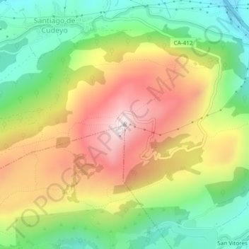
Name: Pico Llen topographic map, elevation, terrain.
Average elevation: 873 ft
Minimum elevation: 52 ft
Maximum elevation: 1,847 ft
Make a donation
Gear up for your next adventure:
As an Amazon Associate, this site earns from qualifying purchases at no extra cost to you.