
Make a donation
Gear up for your next adventure:
As an Amazon Associate, this site earns from qualifying purchases at no extra cost to you.
Zalău topographic map
Click on the map to display elevation.
Make a donation
Gear up for your next adventure:
As an Amazon Associate, this site earns from qualifying purchases at no extra cost to you.
Zalău
The city includes a total surface of 90.09 km2 (34.78 sq mi). This includes the one village it administers, Stâna (Felsőnyárló), situated south-east of Meseș, in the hydrographic basin of the Agrij River. Măgura Stânii is at an altitude of 716 m (2,349 ft).
Make a donation
Gear up for your next adventure:
As an Amazon Associate, this site earns from qualifying purchases at no extra cost to you.
About this map
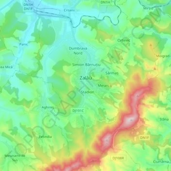
Name: Zalău topographic map, elevation, terrain.
Location: Zalău, Sălaj, Romania (47.11940 23.00067 47.23329 23.17401)
Average elevation: 1,135 ft
Minimum elevation: 669 ft
Maximum elevation: 2,365 ft
Make a donation
Gear up for your next adventure:
As an Amazon Associate, this site earns from qualifying purchases at no extra cost to you.
Other topographic maps
Click on a map to view its topography, its elevation and its terrain.