Geolocate

Minabang topographic map

Click on the map to display elevation.

About this map

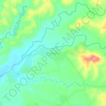
Name: Minabang topographic map, elevation, terrain.

Location: Minabang, Ilagan, Isabela, Cagayan Valley, Philippines (17.16402 121.92223 17.20402 121.96223)

Average elevation: 249 ft

Minimum elevation: 135 ft

Maximum elevation: 495 ft

Other topographic maps

Click on a map to view its topography, its elevation and its terrain.

Abuan River

Philippines > Isabela > Ilagan

Average elevation: 617 ft

Gear up for your next adventure:

📡Handheld GPS Device - Reliable handheld GPS for outdoor navigation
🔥Camping Stove - Portable stove for camping and backcountry cooking
📦Gear Storage Bags - Organize and protect outdoor equipment
🛠️Outdoor Gear Repair Kit - Essential tools to fix gear on the trail
Solar GPS Watches - Advanced multisport watches with built-in topographic maps

As an Amazon Associate, this site earns from qualifying purchases at no extra cost to you.