Geolocate

2nd district topographic map

Click on the map to display elevation.

About this map

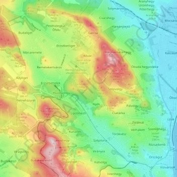
Name: 2nd district topographic map, elevation, terrain.

Location: 2nd district, Budapest, Central Hungary, Hungary (47.50607 18.92511 47.57891 19.04271)

Average elevation: 827 ft

Minimum elevation: 328 ft

Maximum elevation: 1,683 ft

Other topographic maps

Click on a map to view its topography, its elevation and its terrain.

Háros-sziget

Hungary > Budapest

Average elevation: 522 ft

Danube

Hungary > Budapest

Average elevation: 410 ft

Gear up for your next adventure:

🎁Geography Themed Gifts - Unique gift ideas for map lovers and geography enthusiasts
🪄Magnetic Compass - Accurate compass for navigation
📷Action Camera - Capture your outdoor adventures in HD
👓Polarized Sunglasses - Outdoor sunglasses for glare reduction
🧯Emergency Survival Kit - All‑in‑one survival essentials for the backcountry

As an Amazon Associate, this site earns from qualifying purchases at no extra cost to you.