
Make a donation
Gear up for your next adventure:
As an Amazon Associate, this site earns from qualifying purchases at no extra cost to you.
Bezirk Laufen topographic map
Click on the map to display elevation.
Make a donation
Gear up for your next adventure:
As an Amazon Associate, this site earns from qualifying purchases at no extra cost to you.
About this map
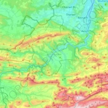
Name: Bezirk Laufen topographic map, elevation, terrain.
Location: Bezirk Laufen, Basel-Landschaft, Schweiz (47.37940 7.32528 47.47045 7.62607)
Average elevation: 1,831 ft
Minimum elevation: 883 ft
Maximum elevation: 3,970 ft
Make a donation
Gear up for your next adventure:
As an Amazon Associate, this site earns from qualifying purchases at no extra cost to you.
Other topographic maps
Click on a map to view its topography, its elevation and its terrain.
Make a donation
Gear up for your next adventure:
As an Amazon Associate, this site earns from qualifying purchases at no extra cost to you.
Belchenflue
Schweiz > Basel-Landschaft > Bezirk Waldenburg > Eptingen
Begrenzt wird die Belchenflue im Norden durch den Talkessel von Eptingen. Im Süden verlaufen mehrere Kämme mit dazwischengeschalteten Talmulden und Ausräumungskesseln parallel, bevor das Gelände steil zum Schweizer Mittelland hin abfällt. Die Belchenflue ist charakterisiert durch eine gegen Norden…
Average elevation: 2,831 ft
Oberer Hauenstein
Schweiz > Basel-Landschaft > Bezirk Waldenburg > Langenbruck
Oberer Hauenstein, Passhöhe
Average elevation: 2,661 ft