
Make a donation
Gear up for your next adventure:
As an Amazon Associate, this site earns from qualifying purchases at no extra cost to you.
Ahipara topographic map
Click on the map to display elevation.
Make a donation
Gear up for your next adventure:
As an Amazon Associate, this site earns from qualifying purchases at no extra cost to you.
About this map
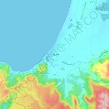
Name: Ahipara topographic map, elevation, terrain.
Average elevation: 197 ft
Minimum elevation: -3 ft
Maximum elevation: 1,096 ft
Make a donation
Gear up for your next adventure:
As an Amazon Associate, this site earns from qualifying purchases at no extra cost to you.
Other topographic maps
Click on a map to view its topography, its elevation and its terrain.
Ahiaruhe Shell Bank
New Zealand > Northland > Far North District > Te Hiku Community
Average elevation: 10 ft
Lake Waiparera
New Zealand > Northland > Far North District > Te Hiku Community
Average elevation: 105 ft
Victoria River
New Zealand > Northland > Far North District > Te Hiku Community
Average elevation: 390 ft