Geolocate

Wembdon topographic map

Click on the map to display elevation.

About this map

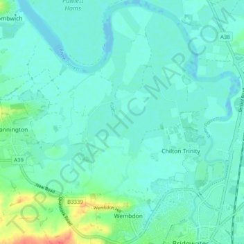
Name: Wembdon topographic map, elevation, terrain.

Location: Wembdon, Sedgemoor, Somerset, England, United Kingdom (51.12811 -3.04996 51.17709 -3.00197)

Average elevation: 30 ft

Minimum elevation: -26 ft

Maximum elevation: 157 ft

Other topographic maps

Click on a map to view its topography, its elevation and its terrain.

Highbridge

United Kingdom > England > Somerset > Sedgemoor > Highbridge

Average elevation: 20 ft

Gear up for your next adventure:

Backpacking Tents - Weight-optimized shelters for multi-day topographic surveys
🧣Hiking Neck Gaiter - Multi‑use neck protection for outdoor weather
🧢Outdoor Hiking Hat - Sun protection hat for outdoor explorers
🥾Women's Hiking Boots - Top-rated trail boots with ankle support and superior grip
🥤Water Filter Bottle - All‑in‑one filter bottle for safe hydration

As an Amazon Associate, this site earns from qualifying purchases at no extra cost to you.