
Make a donation
Gear up for your next adventure:
As an Amazon Associate, this site earns from qualifying purchases at no extra cost to you.
Ciudad Reformadores topographic map
Click on the map to display elevation.
Make a donation
Gear up for your next adventure:
As an Amazon Associate, this site earns from qualifying purchases at no extra cost to you.
About this map
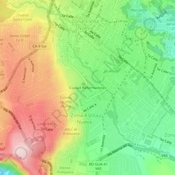
Name: Ciudad Reformadores topographic map, elevation, terrain.
Average elevation: 4,439 ft
Minimum elevation: 3,907 ft
Maximum elevation: 5,079 ft
Make a donation
Gear up for your next adventure:
As an Amazon Associate, this site earns from qualifying purchases at no extra cost to you.
Other topographic maps
Click on a map to view its topography, its elevation and its terrain.
Zona 12 de Villa Nueva
Guatemala > Departamento de Guatemala > Villa Nueva
Average elevation: 4,541 ft
Make a donation
Gear up for your next adventure:
As an Amazon Associate, this site earns from qualifying purchases at no extra cost to you.
Zona 10 de Villa Nueva
Guatemala > Departamento de Guatemala > Villa Nueva
Average elevation: 4,534 ft
Zona 11 de Villa Nueva
Guatemala > Departamento de Guatemala > Villa Nueva > Zona 11 de Villa Nueva
Average elevation: 4,642 ft
Make a donation
Gear up for your next adventure:
As an Amazon Associate, this site earns from qualifying purchases at no extra cost to you.
Make a donation
Gear up for your next adventure:
As an Amazon Associate, this site earns from qualifying purchases at no extra cost to you.
Zona 10 de Villa Nueva
Guatemala > Departamento de Guatemala > Villa Nueva
Average elevation: 4,534 ft
Zona 12 de Villa Nueva
Guatemala > Departamento de Guatemala > Villa Nueva
Average elevation: 4,541 ft
Make a donation
Gear up for your next adventure:
As an Amazon Associate, this site earns from qualifying purchases at no extra cost to you.