
Make a donation
Gear up for your next adventure:
As an Amazon Associate, this site earns from qualifying purchases at no extra cost to you.
Mitte topographic map
Click on the map to display elevation.
Make a donation
Gear up for your next adventure:
As an Amazon Associate, this site earns from qualifying purchases at no extra cost to you.
Mitte
Der Bielefelder Stadtbezirk Mitte liegt an der Nordostseite des Teutoburger Waldes im Ravensberger Hügelland vor dem nördlichen Ausgang des Bielefelder Passes. Der Teutoburger Wald nimmt am südwestlichen Rand des Stadtbezirks Höhen bis etwa 200 m an. Es gibt keinen größeren Fluss im Stadtbezirk; einige Bäche wie Lutterbach, Baderbach, Mühlenbach, Finkenbach und Wellbach entwässern das Gebiet dem natürlichen Gefälle folgend in nordöstlicher Richtung zur Weser hin.
Make a donation
Gear up for your next adventure:
As an Amazon Associate, this site earns from qualifying purchases at no extra cost to you.
About this map
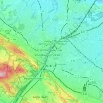
Name: Mitte topographic map, elevation, terrain.
Location: Mitte, Bielefeld, Nordrhein-Westfalen, Deutschland (51.99997 8.50693 52.05333 8.58855)
Average elevation: 427 ft
Minimum elevation: 266 ft
Maximum elevation: 938 ft
Make a donation
Gear up for your next adventure:
As an Amazon Associate, this site earns from qualifying purchases at no extra cost to you.
Other topographic maps
Click on a map to view its topography, its elevation and its terrain.
Burg und Festung Sparrenberg
Deutschland > Nordrhein-Westfalen > Bielefeld
Um den Erhalt und die Sanierung der Anlage finanziell sicherzustellen, wurde die Aktion Ein Stein für die Burg initiiert, bei der gegen Geldspenden die Patenschaft für einen Stein in der Burgmauer übernommen werden konnte. Bei höheren Spendensummen war eine persönliche Gravur des Steins möglich.…
Average elevation: 476 ft
Make a donation
Gear up for your next adventure:
As an Amazon Associate, this site earns from qualifying purchases at no extra cost to you.