Geolocate

Marsden topographic map

Click on the map to display elevation.

About this map

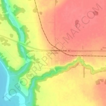
Name: Marsden topographic map, elevation, terrain.

Location: Marsden, Division No. 13, Saskatchewan, Canada (52.83752 -109.83808 52.84546 -109.81023)

Average elevation: 2,100 ft

Minimum elevation: 1,962 ft

Maximum elevation: 2,169 ft

Other topographic maps

Click on a map to view its topography, its elevation and its terrain.

Coleville

Canada > Saskatchewan > Division No. 13

Average elevation: 2,323 ft

Gear up for your next adventure:

🌲Outdoor Survival Books - Best books on survival skills
🌡️Handheld Weather Meters - Measure wind, temp, and pressure for safe mountain travel
📦Gear Storage Bags - Organize and protect outdoor equipment
🔥Plasma Lighters - Windproof lighters that work in any weather condition
🪶Fire Starter Kit - Reliable fire starter for survival and camping

As an Amazon Associate, this site earns from qualifying purchases at no extra cost to you.