Geolocate

Castleton topographic map

Click on the map to display elevation.

About this map

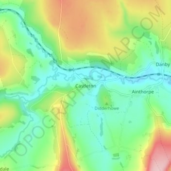
Name: Castleton topographic map, elevation, terrain.

Location: Castleton, Scarborough, North Yorkshire, England, YO21 2EF, United Kingdom (54.44344 -0.96032 54.48344 -0.92032)

Average elevation: 614 ft

Minimum elevation: 400 ft

Maximum elevation: 1,014 ft

Other topographic maps

Click on a map to view its topography, its elevation and its terrain.

Gear up for your next adventure:

🧦Merino Wool Socks - Moisture-wicking, blister-preventing socks for long treks
🔪Outdoor Multitools - Essential survival tools for gear repair and field use
🚑Emergency Bivvies - Heat-reflective sleeping bags for survival situations
🧯Portable Fire Pit - Compact fire pit for camping spots
🛌Ultralight Sleeping Bags - Compact down bags for cold nights in the wilderness

As an Amazon Associate, this site earns from qualifying purchases at no extra cost to you.