Geolocate

Mitchelton topographic map

Click on the map to display elevation.

About this map

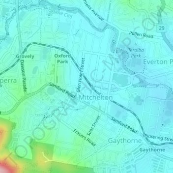
Name: Mitchelton topographic map, elevation, terrain.

Location: Mitchelton, City of Brisbane, Queensland, Australia (-27.42390 152.95732 -27.39684 152.98328)

Average elevation: 180 ft

Minimum elevation: 92 ft

Maximum elevation: 705 ft

Other topographic maps

Click on a map to view its topography, its elevation and its terrain.

Bulimba Creek

Australia > Queensland > City of Brisbane

Average elevation: 36 ft

Tangalooma

Australia > Queensland > City of Brisbane

Average elevation: 135 ft

Enoggera Hill

Australia > Queensland > City of Brisbane

Average elevation: 374 ft

Toohey Mountain

Australia > Queensland > City of Brisbane

Average elevation: 174 ft

Enoggera Dam

Australia > Queensland > City of Brisbane

Average elevation: 295 ft

Wilcannia Park

Australia > Queensland > City of Brisbane

Average elevation: 249 ft

Tangalooma

Australia > Queensland > City of Brisbane

Average elevation: 135 ft

Blunder Creek

Australia > Queensland > City of Brisbane

Average elevation: 85 ft

Deepwater Bend

Australia > Queensland > City of Brisbane

Average elevation: 16 ft

Timberland Park

Australia > Queensland > City of Brisbane

Average elevation: 121 ft

Gear up for your next adventure:

🎒Day Hiking Backpack - Lightweight backpack perfect for day trips and outdoor adventures
🧭GPS Watch Accessories - Bands and chargers for GPS watches
❄️Traction Cleats - Prevent slips on icy trails during winter hikes
👓Polarized Sunglasses - Outdoor sunglasses for glare reduction
🧦Hiking Socks - Comfortable socks to prevent blisters on long hikes

As an Amazon Associate, this site earns from qualifying purchases at no extra cost to you.