
Witta topographic map
Click on the map to display elevation.
About this map
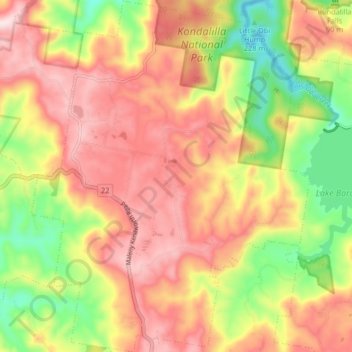
Name: Witta topographic map, elevation, terrain.
Average elevation: 1,115 ft
Minimum elevation: 456 ft
Maximum elevation: 1,657 ft
Other topographic maps
Click on a map to view its topography, its elevation and its terrain.
Sunshine Coast
Australia > Queensland > Sunshine Coast Regional
The Sunshine Coast in Queensland, Australia, showcases a diverse topography that harmoniously blends coastal plains with rugged hinterlands. Along its eastern edge, the region features expansive sandy beaches and coastal dunes that transition smoothly into fertile lowlands. Inland, the terrain becomes more…
Average elevation: 358 ft
Glass House Mountain Lookout
Australia > Queensland > Sunshine Coast Regional
Average elevation: 276 ft
Caloundra
Australia > Queensland > Sunshine Coast Regional
Caloundra, located on Queensland's Sunshine Coast, features a diverse coastal topography characterized by sandy beaches, rocky headlands, and nearby elevated terrains. The suburb of Kings Beach exemplifies this diversity, with its sandy shoreline to the south and southeast, and a rocky headland rising to about…
Average elevation: 16 ft