
Zunyi topographic map
Interactive map
Click on the map to display elevation.
About this map
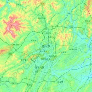
Name: Zunyi topographic map, elevation, terrain.
Location: Zunyi, Guizhou, Chine (27.56380 106.75914 27.88380 107.07914)
Average elevation: 3,176 ft
Minimum elevation: 2,493 ft
Maximum elevation: 5,528 ft
Other topographic maps
Click on a map to view its topography, its elevation and its terrain.
拉赖
Chine > Guizhou > Préfecture autonome buyei et miao de Qiannan > 拉赖
拉赖, Préfecture autonome buyei et miao de Qiannan, Guizhou, 558000, Chine
Average elevation: 3,176 ft
长吉镇
Chine > Guizhou > Préfecture autonome miao et dong de Qiandongnan > 长吉镇
长吉镇, Préfecture autonome miao et dong de Qiandongnan, Guizhou, Chine
Average elevation: 2,156 ft