Geolocate

Sumangga topographic map

Click on the map to display elevation.

About this map

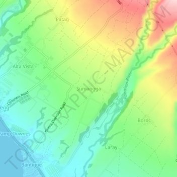
Name: Sumangga topographic map, elevation, terrain.

Location: Sumangga, Ormoc, Leyte, Eastern Visayas, Philippines (10.98679 124.61541 11.02679 124.65541)

Average elevation: 279 ft

Minimum elevation: 0 ft

Maximum elevation: 758 ft

Other topographic maps

Click on a map to view its topography, its elevation and its terrain.

Ormoc City Proper

Philippines > Leyte > Ormoc

Average elevation: 59 ft

Binahaan River

Philippines > Leyte > Ormoc

Average elevation: 1,791 ft

Binahaan River

Philippines > Leyte > Ormoc

Average elevation: 1,624 ft

Gear up for your next adventure:

🔭Compact Binoculars - HD vision for scouting terrain and identifying distant landmarks
🧭GPS Watch Accessories - Bands and chargers for GPS watches
🪶LED Camping Lantern - Bright lantern for camp lighting
🦟Ultrasonic Repellers - Create a bug-free zone at your camp or rest stop
💧Water Filtration Bottles - Safely drink from streams and lakes while exploring

As an Amazon Associate, this site earns from qualifying purchases at no extra cost to you.