
West Kalimantan topographic map
Interactive map
Click on the map to display elevation.
About this map
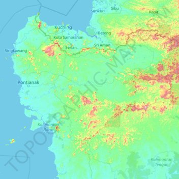
Name: West Kalimantan topographic map, elevation, terrain.
Location: West Kalimantan, Indonesia (-2.69224 108.53689 2.42776 113.65689)
Average elevation: 364 ft
Minimum elevation: -13 ft
Maximum elevation: 6,535 ft
Other topographic maps
Click on a map to view its topography, its elevation and its terrain.
Tapang Pulau
Indonesia > West Kalimantan > Tapang Pulau
Tapang Pulau, Belitang Hilir, Sekadau, West Kalimantan, Indonesia
Average elevation: 79 ft
Kapuas River
Kapuas River, West Kalimantan, 78611, Indonesia
Average elevation: 463 ft