Geolocate

Tickhill topographic map

Click on the map to display elevation.

Tickhill

It lies eight miles south of Doncaster, between Maltby and Harworth, on the busy conjunction of the A631 and A60 roads, and adjacent to the A1(M) motorway. It is located at 53° 26' North, 1° 6' 40" West, at an elevation of around 20 metres above sea level. The River Torne passes close to the south-east of the town where it is the boundary between South Yorkshire and Nottinghamshire, eventually meeting the River Trent.

Wikipedia (CC-BY-SA 3.0)

About this map

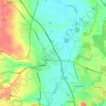
Name: Tickhill topographic map, elevation, terrain.

Location: Tickhill, Doncaster, South Yorkshire, England, United Kingdom (53.40574 -1.15179 53.46823 -1.05201)

Average elevation: 92 ft

Minimum elevation: 10 ft

Maximum elevation: 249 ft

Other topographic maps

Click on a map to view its topography, its elevation and its terrain.

Mexborough

United Kingdom > England > Doncaster

Average elevation: 154 ft

Edenthorpe

United Kingdom > England > Doncaster

Average elevation: 36 ft

Cantley Park

United Kingdom > England > Doncaster > Old Cantley

Average elevation: 39 ft

Conisbrough

United Kingdom > England > Doncaster

Average elevation: 200 ft

Arksey

United Kingdom > England > Doncaster

Average elevation: 26 ft

Harlington

United Kingdom > England > Doncaster

Average elevation: 135 ft

Clifton

United Kingdom > England > Doncaster

Average elevation: 305 ft

Cusworth

United Kingdom > England > Doncaster

Average elevation: 82 ft

Woodlands

United Kingdom > England > Doncaster

Average elevation: 98 ft

Old Denaby

United Kingdom > England > Doncaster

Average elevation: 125 ft

Carcroft

United Kingdom > England > Doncaster

Average elevation: 56 ft

Barnby Dun

United Kingdom > England > Doncaster

Average elevation: 26 ft

Sprotbrough

United Kingdom > England > Doncaster

Average elevation: 128 ft

Scawsby

United Kingdom > England > Doncaster

Average elevation: 82 ft

Tickhill Castle

United Kingdom > England > Doncaster > Tickhill

Average elevation: 69 ft

Hatfield Woodhouse

United Kingdom > England > Doncaster

Average elevation: 13 ft

Moorends

United Kingdom > England > Doncaster

Average elevation: 10 ft

Hatfield

United Kingdom > England > Doncaster

Average elevation: 20 ft

Skellow

United Kingdom > England > Doncaster

Average elevation: 98 ft

Adwick le Street

United Kingdom > England > Doncaster

Average elevation: 66 ft

Adwick le Street

United Kingdom > England > Doncaster

Average elevation: 66 ft

Sprotbrough

United Kingdom > England > Doncaster

Average elevation: 128 ft

New Rossington

United Kingdom > England > Doncaster

Average elevation: 39 ft

Conisbrough

United Kingdom > England > Doncaster

Average elevation: 200 ft

Gear up for your next adventure:

Backpacking Tents - Weight-optimized shelters for multi-day topographic surveys
🔥Camping Stove - Portable stove for camping and backcountry cooking
🔥Fast-Boil Camping Stoves - Efficient cooking systems for quick trail meals
🧴Hand Sanitizer - Keep hands clean while hiking
🌲Outdoor Survival Books - Best books on survival skills

As an Amazon Associate, this site earns from qualifying purchases at no extra cost to you.