
Make a donation
Gear up for your next adventure:
As an Amazon Associate, this site earns from qualifying purchases at no extra cost to you.
Glöbusch topographic map
Click on the map to display elevation.
Make a donation
Gear up for your next adventure:
As an Amazon Associate, this site earns from qualifying purchases at no extra cost to you.
Glöbusch
Glöbusch ist ein Ortsteil in Unterodenthal in der Gemeinde Odenthal im Rheinisch-Bergischen Kreis. Er liegt auf der Höhe an der Bergstraße, die von Odenthal nach Burscheid führt.
Make a donation
Gear up for your next adventure:
As an Amazon Associate, this site earns from qualifying purchases at no extra cost to you.
About this map
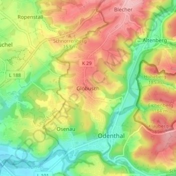
Name: Glöbusch topographic map, elevation, terrain.
Average elevation: 446 ft
Minimum elevation: 217 ft
Maximum elevation: 692 ft
Make a donation
Gear up for your next adventure:
As an Amazon Associate, this site earns from qualifying purchases at no extra cost to you.
Other topographic maps
Click on a map to view its topography, its elevation and its terrain.
Scherfbachtal
Deutschland > Nordrhein-Westfalen > Rheinisch-Bergischer Kreis > Odenthal > Höffe
Average elevation: 541 ft
Unterbreidbach
Deutschland > Nordrhein-Westfalen > Rheinisch-Bergischer Kreis > Odenthal > Neschen > Unterbreidbach
Average elevation: 650 ft