
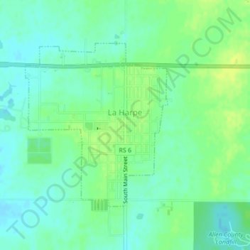
La Harpe topographic map
Interactive map
Click on the map to display elevation.
About this map
Name: La Harpe topographic map, elevation, terrain.
Location: La Harpe, Allen County, Kansas, 66751, United States (37.90678 -95.31282 37.92442 -95.29330)
Average elevation: 1,027 ft
Minimum elevation: 1,001 ft
Maximum elevation: 1,063 ft
Other topographic maps
Click on a map to view its topography, its elevation and its terrain.
Elsmore
United States > Kansas > Allen County
Elsmore, Allen County, Kansas, United States
Average elevation: 1,056 ft
Bassett
United States > Kansas > Allen County
Bassett, Allen County, Kansas, United States
Average elevation: 965 ft
Humboldt
United States > Kansas > Allen County
Humboldt, Allen County, Kansas, United States
Average elevation: 961 ft
Gas
United States > Kansas > Allen County
Gas, Allen County, Kansas, 66742, United States
Average elevation: 1,017 ft
Savonburg
United States > Kansas > Allen County
Savonburg, Allen County, Kansas, United States
Average elevation: 1,043 ft
Moran
United States > Kansas > Allen County
Moran, Allen County, Kansas, United States
Average elevation: 1,096 ft
Iola
United States > Kansas > Allen County
Iola, Allen County, Kansas, 66749, United States
Average elevation: 971 ft