
Make a donation
Gear up for your next adventure:
As an Amazon Associate, this site earns from qualifying purchases at no extra cost to you.
Oberägeri topographic map
Click on the map to display elevation.
Make a donation
Gear up for your next adventure:
As an Amazon Associate, this site earns from qualifying purchases at no extra cost to you.
Oberägeri
The municipality is located in the eastern pre-alpine, high valley on the northern shores of the Ägerisee at an elevation of about 724 m (2,375 ft). It consists of the village of Oberägeri and the hamlets of Morgarten/Hauptsee and Alosen (at an elevation of 897 m (2,943 ft)) as well as scattered farm houses.
Make a donation
Gear up for your next adventure:
As an Amazon Associate, this site earns from qualifying purchases at no extra cost to you.
About this map
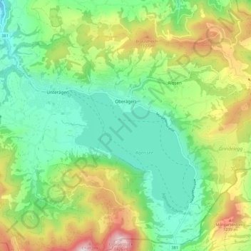
Name: Oberägeri topographic map, elevation, terrain.
Location: Oberägeri, Zug, 6315, Switzerland (47.09200 8.59451 47.16348 8.70116)
Average elevation: 2,992 ft
Minimum elevation: 2,083 ft
Maximum elevation: 4,744 ft
Make a donation
Gear up for your next adventure:
As an Amazon Associate, this site earns from qualifying purchases at no extra cost to you.
Other topographic maps
Click on a map to view its topography, its elevation and its terrain.
Make a donation
Gear up for your next adventure:
As an Amazon Associate, this site earns from qualifying purchases at no extra cost to you.