Geolocate

Saxe topographic map

Click on the map to display elevation.

About this map

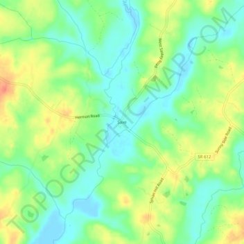
Name: Saxe topographic map, elevation, terrain.

Location: Saxe, Charlotte County, Virginia, 23962, United States (36.90987 -78.68334 36.94987 -78.64334)

Average elevation: 384 ft

Minimum elevation: 318 ft

Maximum elevation: 472 ft

Charlotte County trails, hiking, mountain biking, running and outdoor activities

Other topographic maps

Click on a map to view its topography, its elevation and its terrain.

Keysville

United States > Virginia > Charlotte County

Average elevation: 614 ft

Phenix

United States > Virginia > Charlotte County

Average elevation: 436 ft

Drakes Branch

United States > Virginia > Charlotte County

Average elevation: 443 ft

Gear up for your next adventure:

🚪Portable Camp Chair - Foldable chair for comfort at camp
🦺Reflective Outdoor Gear - Safety gear for low‑light conditions
🎒Hydration Pack - Hands‑free water reservoir for long hikes
🚁Photography Drones - Capture stunning aerial views of landforms and topography
🌎3D Topographic Globes - Raised relief globes for a tactile understanding of geography

As an Amazon Associate, this site earns from qualifying purchases at no extra cost to you.