
Make a donation
Gear up for your next adventure:
As an Amazon Associate, this site earns from qualifying purchases at no extra cost to you.
Dielheim topographic map
Click on the map to display elevation.
Make a donation
Gear up for your next adventure:
As an Amazon Associate, this site earns from qualifying purchases at no extra cost to you.
About this map
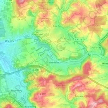
Name: Dielheim topographic map, elevation, terrain.
Average elevation: 587 ft
Minimum elevation: 387 ft
Maximum elevation: 843 ft
Make a donation
Gear up for your next adventure:
As an Amazon Associate, this site earns from qualifying purchases at no extra cost to you.
Other topographic maps
Click on a map to view its topography, its elevation and its terrain.
Neckar-Wimmersbach
Deutschland > Baden-Württemberg > Rhein-Neckar-Kreis > Eberbach
Average elevation: 840 ft
Eiterbach
Deutschland > Baden-Württemberg > Rhein-Neckar-Kreis
Nördlich von Eiterbach liegt am Rande eines ausgedehnten Bergwaldgebietes um die Stiefelhöhe an deren östlichem Abhang in einem kleinen Seitental die romanische Kirchruine und Wallfahrtsstätte St. Maria in Lichtenklingen. Ein Parkplatz am Ende der nördlichen Sackstraße ins Tal, bereits in Hessen,…
Average elevation: 1,388 ft
Moosbrunn
Deutschland > Baden-Württemberg > Rhein-Neckar-Kreis > Moosbrunn
Average elevation: 1,129 ft
Hardtwaldsiedlung
Deutschland > Baden-Württemberg > Rhein-Neckar-Kreis > Oftersheim
Average elevation: 341 ft
Make a donation
Gear up for your next adventure:
As an Amazon Associate, this site earns from qualifying purchases at no extra cost to you.