Geolocate

Hama topographic map

Click on the map to display elevation.

About this map

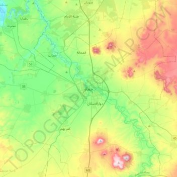
Name: Hama topographic map, elevation, terrain.

Location: Hama, Hama Subdistrict, Hama District, Hama Governorate, Syria (34.97434 36.58963 35.29434 36.90963)

Average elevation: 1,191 ft

Minimum elevation: 607 ft

Maximum elevation: 2,277 ft

Other topographic maps

Click on a map to view its topography, its elevation and its terrain.

Kafr Zita Subdistrict

Syria > Hama Governorate

Average elevation: 942 ft

Gear up for your next adventure:

🏫Relief Map Kits - Hands-on tools for teaching landforms and elevation
🔭Telescopic Hiking Pole - Adjustable pole for hiking stability
🎒Outdoor Daypacks - Lightweight backpacks designed for carrying maps and essential gear
🍳Camping Cook Set - Complete cookware for outdoor meals
📱Solar Portable Charger - Solar power bank for charging devices off‑grid

As an Amazon Associate, this site earns from qualifying purchases at no extra cost to you.