
Make a donation
Gear up for your next adventure:
As an Amazon Associate, this site earns from qualifying purchases at no extra cost to you.
Dusseldorf topographic map
Click on the map to display elevation.
Make a donation
Gear up for your next adventure:
As an Amazon Associate, this site earns from qualifying purchases at no extra cost to you.
Dusseldorf
In 1186, Düsseldorf came under the rule of the Counts of Berg. 14 August 1288 is one of the most important dates in the history of Düsseldorf, the day the sovereign Count Adolf VIII of Berg granted town privileges to the village on the banks of the Düssel. Before this, a bloody struggle for power had taken place between the Archbishop of Cologne and his allies arrayed against the count of Berg and other local powers, culminating in the Battle of Worringen. The Archbishop of Cologne's forces were wiped out by the forces of the count of Berg, who were supported by citizens and farmers of Cologne and Düsseldorf, paving the way for Düsseldorf's elevation to city status, which is commemorated today by a monument on the Burgplatz.
Make a donation
Gear up for your next adventure:
As an Amazon Associate, this site earns from qualifying purchases at no extra cost to you.
About this map
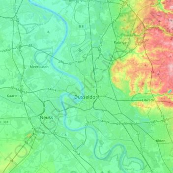
Name: Dusseldorf topographic map, elevation, terrain.
Location: Dusseldorf, North Rhine-Westphalia, Germany (51.12437 6.68881 51.35249 6.93993)
Average elevation: 177 ft
Minimum elevation: 56 ft
Maximum elevation: 617 ft
Make a donation
Gear up for your next adventure:
As an Amazon Associate, this site earns from qualifying purchases at no extra cost to you.
Other topographic maps
Click on a map to view its topography, its elevation and its terrain.