Geolocate
👉 Easily get elevation data in JSON, GeoTIFF and KML formats using Elevation API
Thank you for supporting this site ❤️
Make a donation

Hartenbos topographic map

Click on the map to display elevation.

About this map

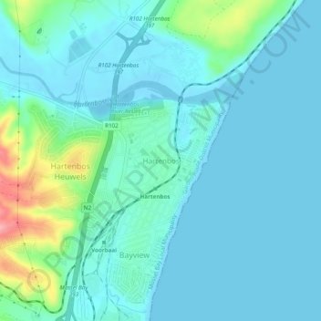
Name: Hartenbos topographic map, elevation, terrain.

Location: Hartenbos, George, Western Cape, 6500, South Africa (-34.14522 22.09344 -34.10522 22.13344)

Average elevation: 66 ft

Minimum elevation: -10 ft

Maximum elevation: 384 ft

Other topographic maps

Click on a map to view its topography, its elevation and its terrain.

Touwsranten

South Africa > Western Cape > George

Average elevation: 663 ft

Danabaai

South Africa > Western Cape > George

Average elevation: 358 ft

Oudtshoorn

South Africa > Western Cape > George

Average elevation: 1,158 ft

Oudtshoorn

South Africa > Western Cape > George

Average elevation: 1,158 ft

Friemersheim

South Africa > Western Cape > George

Average elevation: 860 ft

Oudtshoorn

South Africa > Western Cape > George

Average elevation: 1,158 ft

Garden Route Dam

South Africa > Western Cape > George

Average elevation: 656 ft

Gear up for your next adventure:

🏕️Family Camping Gear - Essentials for group camping trips
🕶️GPS Smartphone Mount - Secure mount for phone navigation
☀️Outdoor Sunscreen - High protection sunscreen for outdoor activities
🎒Outdoor Daypacks - Lightweight backpacks designed for carrying maps and essential gear
🛡️Bear Spray Outdoor - Protection in bear country hikes

As an Amazon Associate, this site earns from qualifying purchases at no extra cost to you.