
Make a donation
Gear up for your next adventure:
As an Amazon Associate, this site earns from qualifying purchases at no extra cost to you.
Fontao topographic map
Click on the map to display elevation.
Make a donation
Gear up for your next adventure:
As an Amazon Associate, this site earns from qualifying purchases at no extra cost to you.
About this map
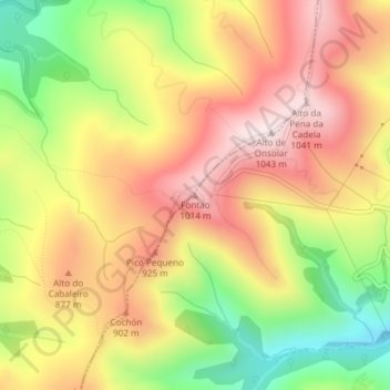
Name: Fontao topographic map, elevation, terrain.
Location: Fontao, O Valadouro, Mariña Central, Lugo, Galicia, España (43.49301 -7.56136 43.49311 -7.56126)
Average elevation: 2,644 ft
Minimum elevation: 1,736 ft
Maximum elevation: 3,392 ft
Make a donation
Gear up for your next adventure:
As an Amazon Associate, this site earns from qualifying purchases at no extra cost to you.
Other topographic maps
Click on a map to view its topography, its elevation and its terrain.
Burela
España > Galicia > Mariña Central
La localidad capital del municipio está situada en el norte de la provincia de Lugo en la costa del mar Cantábrico a una altitud de 25 m s. n. m.. El municipio limita al norte y al este con el mar Cantábrico, al sur con Foz y al oeste con Cervo.
Average elevation: 259 ft
Mondoñedo
España > Galicia > Mariña Central
El relieve del municipio es irregular, con zonas montañosas y valles labrados por pequeños ríos y regatos. El río Masma es el curso de agua más importante, el cual se forma por la unión de varios regatos que nacen de las sierras cercanas. La serra da Toxiza ocupa la zona noroccidental mientras que por el…
Average elevation: 1,168 ft
Make a donation
Gear up for your next adventure:
As an Amazon Associate, this site earns from qualifying purchases at no extra cost to you.
Alfoz de Castro de Ouro
España > Galicia > Mariña Central
El castillo de 80 metros de altitud se encuentra en la parroquia de San Salvador de Castro de Ouro. Su estructura se denomina simple y de planta cuadrada. El castillo se encuentra organizado alrededor de su torre central. En sus inmediaciones se encuentra un perímetro de torreones circulares, se conserva uno…
Average elevation: 978 ft
Lourenzá
España > Galicia > Mariña Central
El valle del río Masma ocupa la mayor parte del territorio, además de las sierras del Macizo Galaico que lo limitan, entre las que destaca la sierra da Cadeira al este, en el límite con Trabada. En la dirección suroeste-noroeste discurre el río Baos desde su nacimiento en el municipio de Mondoñedo, hasta…
Average elevation: 853 ft
Make a donation
Gear up for your next adventure:
As an Amazon Associate, this site earns from qualifying purchases at no extra cost to you.
Make a donation
Gear up for your next adventure:
As an Amazon Associate, this site earns from qualifying purchases at no extra cost to you.
Lourenzá
España > Galicia > Mariña Central
El valle del río Masma ocupa la mayor parte del territorio, además de las sierras del Macizo Galaico que lo limitan, entre las que destaca la sierra da Cadeira al este, en el límite con Trabada. En la dirección suroeste-noroeste discurre el río Baos desde su nacimiento en el municipio de Mondoñedo, hasta…
Average elevation: 853 ft
Mondoñedo
España > Galicia > Mariña Central
El relieve del municipio es irregular, con zonas montañosas y valles labrados por pequeños ríos y regatos. El río Masma es el curso de agua más importante, el cual se forma por la unión de varios regatos que nacen de las sierras cercanas. La serra da Toxiza ocupa la zona noroccidental mientras que por el…
Average elevation: 1,168 ft
Make a donation
Gear up for your next adventure:
As an Amazon Associate, this site earns from qualifying purchases at no extra cost to you.
Alfoz de Castro de Ouro
España > Galicia > Mariña Central
El castillo de 80 metros de altitud se encuentra en la parroquia de San Salvador de Castro de Ouro. Su estructura se denomina simple y de planta cuadrada. El castillo se encuentra organizado alrededor de su torre central. En sus inmediaciones se encuentra un perímetro de torreones circulares, se conserva uno…
Average elevation: 978 ft