Geolocate

Tral topographic map

Click on the map to display elevation.

About this map

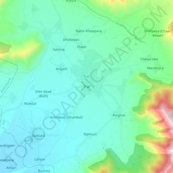
Name: Tral topographic map, elevation, terrain.

Location: Tral, Pulwama District, Jammu and Kashmir, 192123, India (33.88655 75.07404 33.96655 75.15404)

Average elevation: 5,876 ft

Minimum elevation: 5,249 ft

Maximum elevation: 8,428 ft

Other topographic maps

Click on a map to view its topography, its elevation and its terrain.

Batagund

India > Jammu and Kashmir > Tral

Average elevation: 5,810 ft

Gear up for your next adventure:

👓Polarized Sunglasses - Outdoor sunglasses for glare reduction
🪓Survival Multi‑Tool - Versatile tool for camp and trail tasks
🥾Hiking Shoes - Durable and comfortable shoes for trail hiking
☀️Outdoor Sunscreen - High protection sunscreen for outdoor activities
🩳Quick‑Dry Hiking Shorts - Comfortable and quick‑dry shorts for summer hiking

As an Amazon Associate, this site earns from qualifying purchases at no extra cost to you.