
Port Beach topographic map
Interactive map
Click on the map to display elevation.
About this map
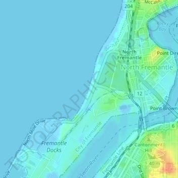
Name: Port Beach topographic map, elevation, terrain.
Average elevation: 16 ft
Minimum elevation: -30 ft
Maximum elevation: 131 ft
Other topographic maps
Click on a map to view its topography, its elevation and its terrain.
Fremantle
Australia > Western Australia > City of Fremantle > Fremantle
Fremantle, City of Fremantle, Western Australia, 6959, Australia
Average elevation: 36 ft
Beaconsfield
Australia > Western Australia > City of Fremantle
Beaconsfield, City of Fremantle, Western Australia, Australia
Average elevation: 75 ft
North Fremantle
Australia > Western Australia > City of Fremantle
North Fremantle, City of Fremantle, Western Australia, 6159, Australia
Average elevation: 39 ft
White Gum Valley
Australia > Western Australia > City of Fremantle
White Gum Valley, City of Fremantle, Western Australia, Australia
Average elevation: 98 ft
Fremantle
Australia > Western Australia > City of Fremantle
Fremantle, City of Fremantle, Western Australia, Australia
Average elevation: 56 ft
Hilton
Australia > Western Australia > City of Fremantle
Hilton, City of Fremantle, Western Australia, 6183, Australia
Average elevation: 125 ft
South Fremantle
Australia > Western Australia > City of Fremantle
South Fremantle, City of Fremantle, Western Australia, 6162, Australia
Average elevation: 30 ft
Round House
Australia > Western Australia > City of Fremantle > Fremantle
Round House, 15, Captains Lane, Fremantle, City of Fremantle, Western Australia, 6160, Australia
Average elevation: 13 ft